On the public release of carbon dioxide flux estimates
based on the observational data by
the Greenhouse gases Observing SATellite “IBUKI” (GOSAT)
December 5, 2012
National Institute for Environmental Studies (NIES)
Ministry of the Environment, Japan (MOE)
Japan Aerospace Exploration Agency (JAXA)
Ministry of the Environment, Japan (MOE)
Japan Aerospace Exploration Agency (JAXA)
Tatsuya Yokota, Head, Satellite Remote Sensing Section
Center for Global Environmental Research (CGER), NIES
()
Shamil Maksyutov, Head, Biogeochemical Cycle Modeling
and Analysis Section, Center for Global Environmental Research (CGER), NIES
()
Center for Global Environmental Research (CGER), NIES
()
Shamil Maksyutov, Head, Biogeochemical Cycle Modeling
and Analysis Section, Center for Global Environmental Research (CGER), NIES
()
Hiroshi Tsujihara, Director, Office for Global Environment Research, MOE
(: ext. 6730),
Yoshitomo Mori, Deputy Director (ext. 6731),
Atsushi Goto, Chief (ext. 6756)
(: ext. 6730),
Yoshitomo Mori, Deputy Director (ext. 6731),
Atsushi Goto, Chief (ext. 6756)
Public Affairs, Press Group, JAXA ()
The Greenhouse gases Observing SATellite "IBUKI" (GOSAT), developed jointly by the Ministry of the Environment Japan, the National Institute for Environmental Studies, and the Japan Aerospace Exploration Agency (hereinafter the Three Parties), is the world's first satellite designed specifically for monitoring atmospheric carbon dioxide (CO2) and methane (CH4) from space. The satellite has been in operation since its launch on January 23, 2009.
The Three Parties will now publicly distribute the data of global CO2 fluxes on a monthly and regional basis for the one-year period between June 2009 and May 2010. These flux values were estimated from ground-based CO2 monitoring data and improved GOSAT-based CO2 concentration data.
It has been confirmed that uncertainties in CO2 flux estimates can be reduced by the addition of GOSAT data to the ground-based observations. This is the first concrete demonstration of the utility of satellite-based concentration data in the estimation of global CO2 fluxes.
It is expected that this progress in the field of global carbon cycle research will lead to more reliable climate change prediction and to the development of effective environmental policies for mitigating global warming in the future.
In order to obtain better CO2 flux estimates, the Three Parties will continue the effort of refining the data processing algorithms for the retrieval of CO2 concentrations from GOSAT data and the estimation of CO2 fluxes.
1. Summary of the data product release
(1) Net CO2 flux estimates
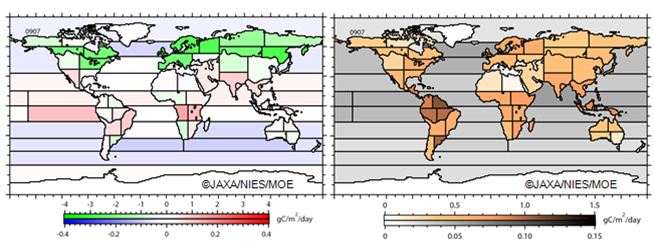
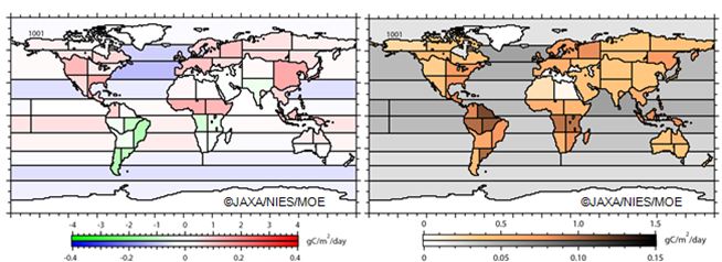
The Three Parties will publicly distribute the monthly estimates of net CO2 fluxes (Note 1) for 64 sub-continental regions from June 2009 to May 2010. These flux values were estimated from the global distribution of CO2 concentration retrieved from GOSAT observational data and ground-based CO2 monitoring data (Note 2), using an atmospheric tracer transport model (Note 3) and a Bayesian inverse modeling scheme (Note 4). Further explanations of the net CO2 flux estimation technique are found in theappendix to this document (attached). As examples, the net CO2 fluxes for July 2009 and January 2010 are presented in Figure 1.
Figure 1 Net CO2 fluxes in 64 regions (left) and their uncertainties (right) estimated from both ground-based monitoring data and GOSAT data. Results for July 2009 (summer in the Northern Hemisphere) and January 2010 (winter in the Northern Hemisphere) are shown. The upper and lower color-coded scales are for land and oceanic regions, respectively. Positive values indicate net emission, and negative values show net absorption. Unit: gC/m2/day (see Note 5 for explanation).
(2) Reduction of uncertainties in flux estimates
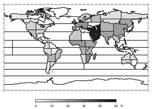
It has been confirmed that uncertainties in CO2 flux estimates can be reduced by as much as 40% (annual average) with the addition of GOSAT data to the ground-based monitoring data. In particular, uncertainties of CO2 fluxes estimated for regions that are not covered by the ground-based monitoring network (e.g. the western seaboard regions of central Africa, southeastern Africa, the Middle and Near East, and India) were reduced by 20-30% (Figure 2). Thanks to these reduced uncertainties, it has become more definite that whether these "blank" regions serve as net sinks or sources of CO2.

Figure 2 Rate of reduction in the uncertainty of monthly surface CO2 flux estimates, achieved by adding GOSAT data to ground-based monitoring data. The values shown are annual means over the analysis period from June 2009 to May 2010.
(3) Simulation of CO2 distribution in the three-dimensional space
Based on the above-mentioned CO2 flux estimates, global three-dimensional CO2distributions have been simulated. These estimated CO2 distributions will now also be released to the general public. It should be noted that these are the products of model simulations and include uncertainties intrinsic to modeling (the results and more details can be found in the appendix). The simulation results will be viewable at the NIES GOSAT Project website, after the statement by the Japanese Minister of the Environment at UNFCCC COP18. (URL: https://data.gosat.nies.go.jp/ – Click on "Gallery" in the left column to access the figures.)
2. Next steps
(1) Expanding temporal coverage
The temporal coverage of the 64-regional net CO2 flux estimates released this time (one year from June 2009 to May 2010) will later be extended to May 2011. The extended results will then be released to affiliated researchers, selected by means of GOSAT Research Announcements for Principal Investigators, in order for these estimates to be evaluated and verified. In addition, we will evaluate the accuracy and consistency of the results by means of comparisons with independent flux estimation results from other research groups. After the evaluation mentioned above, the extended data product will be released to the general public.
Additional information: development of a GOSAT follow-on mission
To further improve the accuracy of global flux estimates, it is required to enhance the capability of space-based greenhouse gas observation that covers the entire globe. Today, only GOSAT carries out this observation in the world. This year, the Three Parties have begun the process of developing GOSAT-2, a GOSAT successor with enhanced observing capabilities, aiming for a launch in 2017.
In developing GOSAT-2, the Three Parties also plan to refine the data processing algorithms used to analyze the satellite observational data and to estimate CO2 fluxes.
As space missions similar to GOSAT-2 are being planned and implemented by the U.S. and by other nations, the Three Parties will seek to broaden the international cooperation on space-based greenhouse gases observation.
Notes
1) Difference between the sum of CO2 emissions (anthropogenic emissions, wildfire emissions, and respiration by soil and terrestrial plants) and that of absorptions (uptake by terrestrial plants and oceans) on a regional basis.
2) Ground-based CO2 network data provided by the U.S. National Oceanic and Atmospheric Administration (GLOBALVIEW-CO2). Data available online athttp://www.esrl.noaa.gov/gmd/ccgg/globalview/index.html.
3) A computer program for modeling the transport and diffusion of atmospheric trace gases such as CO2 and CH4. The program is used to simulate spatial and temporal changes in the distribution of those gases. An atmospheric tracer transport model developed at NIES was used for this analysis. For the atmospheric transport simulations, the JCDAS meteorological data provided by the JRA-25 long-term reanalysis project, promoted by the Japan Meteorological Agency and the Central Research Institute of Electric Power Industry, were used.
4) A scheme based on Bayes' rule to infer parameters from observational data. Detailed explanations on the data processing algorithm can be found in a peer-reviewed paper by Maksyutov et al. (2012): Regional CO2 flux estimates for 2009-2010 based on GOSAT and ground-based CO2observations, Atmos. Chem. Phys. Discuss., 12 29235-29288, doi: 10.5194/acpd-12-29235-2012.
5) gC/m2/day: a unit for net CO2 flux. It expresses the net amount of CO2, converted into the amount of carbon, exchanged in one square meter of surface in one day.
[Appendix]
[Contact Information]
Data analysis results and GOSAT data:
Dr. Tatsuya Yokota, Head, Satellite Remote Sensing Research Section, CGER, NIES / NIES GOSAT Project Leader
Phone:
(during December 3, 2012 and December 7, 2012, only)
(during December 3, 2012 and December 7, 2012, only)
Dr. Shamil Maksyutov, Head, Biogeochemical Cycle Modeling and Analysis Section, CGER, NIES / NIES GOSAT Project Sub-Leader
Phone:
Phone:
GOSAT, onboard sensors, and observation status:
Mr. Masakatsu Nakajima, GOSAT Mission Manager, Satellite Applications and Promotion Center, Space Applications Mission Directorate, JAXA
Phone: (during December 3, 2012 and December 7, 2012)
Phone: (during December 3, 2012 and December 7, 2012)
For more information: http://www.nies.go.jp/whatsnew/2012/20121205-2/20121205-2e.html


0 Comment :
Post a Comment
Thanks for your comment!