Near real-time deforestation monitoring system to go global
Rhett A. Butler, mongabay.comJuly 25, 2013
A near real-time deforestation monitoring system will soon cover all the world's tropical forests, report the researchers behind the initiative.
Terra-i — a collaborative project between Colombia's International Center for Tropical Agriculture (CIAT), the Nature Conservancy (TNC), the School of Business and Engineering (HEIG-VD) in Switzerland, and King’s College London — has been testing its system in tropical Asia, extending its reach beyond its stronghold in Central and South America. Terra-i uses data from NASA's satellite-based MODIS sensors to assess changes in forest cover at a 250-meter resolution every 16 days. The system is similar to the near real-time deforestation tracking system used in Brazil by the government and Imazon, a local NGO.
"We can now provide near real time data on land cover change in Latin America and we expect to be producing pan-tropical results over the next few months," Louis Reymondin, a researcher at CIAT, told mongabay.com. "Since this is the first continental scale system on operation and the first to work outside of the Brazilian Amazon, this allows a similar level of reporting and understanding of land cover change for other countries as Brazil has had in place for some time."
The system detects deforestation based on changes in "greenness" in natural vegetation. It normalizes seasonal vegetation response to rainfall to reduce false positives. The data is then mapped and made available for download viawww.terra-i.org. For Latin America, data is available at the national level and by protected area, ecosystem, and state or municipality.


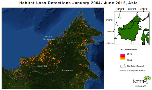
Deforestation in Borneo 2004-2012, according to Terra-i
Reymondin says Terra-i has applications beyond serving as a deforestation alert system.
"Terra-i has a range of applications, such as: monitoring the effectiveness of conservation; assessing the impact on the environment of the construction of new infrastructure like roads; assessing the contribution of deforestation to climate change and understanding the likely impacts of deforestation on downstream and downhill populations."
Terra-i isn't the only near real-time deforestation alert system under development. The World Resources Institute (WRI) is putting the final touches on Global Forest Watch, a tool that will also track deforestation on a bi-weekly basis, while offering layers like plantation concession maps as well as providing a mechanism for users to share photos and reports from the field.
Source: http://news.mongabay.com/2013/0725-terra-i-deforestation-tracking-system.html


0 Comment :
Post a Comment
Thanks for your comment!